Digger Badge: Difference between revisions
imported>SekoiaBot (historical) m (Robot: Automated text replacement (-({{CIT Badge[^}]*}}) +\1\n{{BadgeHunter Badge}})) |
imported>Deviant Girl (historical) m (→Monument 1) |
||
| (12 intermediate revisions by 4 users not shown) | |||
| Line 1: | Line 1: | ||
{{TOCright}} | {{TOCright}} | ||
{{Image|Badge history 01.png}} | |||
== Description == | == Description == | ||
| Line 11: | Line 11: | ||
{{Location_Header|Name=Monument}} | {{Location_Header|Name=Monument}} | ||
{{Location_Row|Name=Digger |Zone=[[Atlas Park]]|Border=1| | {{Location_Row|Name=Digger |Zone=[[Atlas Park]]|Border=1| 1159|42|-812}} | ||
{{Location_Row|Name=Digger |Zone=[[The Hollows]]|Border=1|1351 |11 |-3065 }} | {{Location_Row|Name=Digger |Zone=[[The Hollows]]|Border=1|1351 |11 |-3065 }} | ||
{{Location_Row|Name=Digger |Zone=[[The Hollows]]|Border=1| -2250| 5|-2365 }} | {{Location_Row|Name=Digger |Zone=[[The Hollows]]|Border=1| -2250| 5|-2365 }} | ||
| Line 19: | Line 19: | ||
=== Monument 1 === | === Monument 1 === | ||
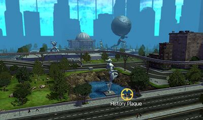
[[ | [[File:Plaque_Digger_1.jpg|right|thumb|400px|Monument 1, located in [[Atlas Park]]. Click image for larger version.]] | ||
'''Inscription''' | '''Inscription''' | ||
| Line 29: | Line 29: | ||
This plaque is in [[Atlas Park]]. | This plaque is in [[Atlas Park]]. | ||
Its [[coordinates]] are | Its [[coordinates]] are {{coords|1159|42|-812}}. It is located 7 feet north of the "Prometheus Park" neighborhood marker, on the overpass overlooking a lake. It is also 112 feet west and slightly north of the Fort Trident marker. | ||
{{clr}} | {{clr}} | ||
=== Monument 2 === | === Monument 2 === | ||
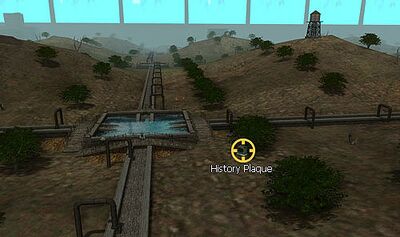
[[ | [[File:Plaque_Digger_2.jpg|right|thumb|400px|Monument 2, located in [[The Hollows]]. Click image for larger version.]] | ||
'''Inscription''' | '''Inscription''' | ||
| Line 43: | Line 44: | ||
This plaque is in [[The Hollows]]. | This plaque is in [[The Hollows]]. | ||
Its [[coordinates]] are | Its [[coordinates]] are {{coords|1351|11|-3065}}. It is 196 yards south of the Cherry Hills neighborhood marker. | ||
{{clr}} | {{clr}} | ||
=== Monument 3 === | === Monument 3 === | ||
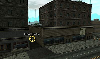
[[ | [[File:Plaque_Digger_3.jpg|right|thumb|400px|Monument 3, located in [[The Hollows]]. Click image for larger version.]] | ||
'''Inscription''' | '''Inscription''' | ||
| Line 57: | Line 58: | ||
This plaque is [[The Hollows]]. | This plaque is [[The Hollows]]. | ||
Its [[coordinates]] are | Its [[coordinates]] are {{coords|-2250|5|-2365}}. It is 740 yards southeast of the Four Seasons neighborhood marker. | ||
{{clr}} | {{clr}} | ||
=== Monument 4 === | === Monument 4 === | ||
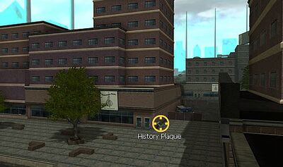
[[ | [[File:Plaque_Digger_4.jpg|right|thumb|400px|Monument 4, located in [[The Hollows]]. Click image for larger version.]] | ||
'''Inscription''' | '''Inscription''' | ||
| Line 71: | Line 72: | ||
This plaque is in [[The Hollows]]. | This plaque is in [[The Hollows]]. | ||
Its [[coordinates]] are | Its [[coordinates]] are {{coords|1612|4|-1949}}. It is 571 yards south of the Cherry Hills neighborhood marker. | ||
{{clr}} | {{clr}} | ||
=== Monument 5 === | === Monument 5 === | ||
[[ | [[File:Plaque_Digger_5.jpg|right|thumb|400px|Monument 5, located in [[The Hollows]]. Click image for larger version.]] | ||
'''Inscription''' | '''Inscription''' | ||
| Line 85: | Line 86: | ||
This plaque is in [[The Hollows]]. | This plaque is in [[The Hollows]]. | ||
Its [[coordinates]] are | Its [[coordinates]] are {{coords|872|68|3344}}. It is 571 yards east and slightly south of the [[Skyway City]] Entrance marker and 714 yards due south of the Red River Marker. | ||
{{clr}} | {{clr}} | ||
| Line 91: | Line 92: | ||
== See Also == | == See Also == | ||
* [[Badges]] | * [[Badges]] | ||
* [[Issue 3 Badges]] | |||
* [[Issue 18 Badges]] | |||
* [[Issue 21 Badges]] | |||
* [[Hero History Badges]] | |||
* [[Villain History Badges]] | |||
== External Links == | == External Links == | ||
| Line 98: | Line 103: | ||
{{BadgeHunter Badge}} | {{BadgeHunter Badge}} | ||
[[Category: | [[Category:Hero History Badges]] | ||
[[Category:Villain History Badges]] | |||
Latest revision as of 02:58, 28 July 2012
Description
You have learned the history behind the Hollowing.
Associated History Monuments
Location Table
| Monument | Zone | Location ( x y z ) |
|---|---|---|
| Digger | Atlas Park | 115942-812[Copy] |
| Digger | The Hollows | 1351 11 -3065 [Copy] |
| Digger | The Hollows | -2250 5-2365 [Copy] |
| Digger | The Hollows | 1612 4 -1949[Copy] |
| Digger | The Hollows | 872 68 3344 [Copy] |
Monument 1
Inscription
On this site, the Trolls Task Force was formed in response to the devastating event known as the Hollowing. Police Chief James Wilson said 'The police department will not stop until the residents of Eastgate can go home again.'
Location
This plaque is in Atlas Park.
Its coordinates are (1159, 42, -812) . It is located 7 feet north of the "Prometheus Park" neighborhood marker, on the overpass overlooking a lake. It is also 112 feet west and slightly north of the Fort Trident marker.
Monument 2
Inscription
This water treatment facility used to desalinate the water from Eastgate Bay for use by Paragon City citizens. In the wake of the Hollowing, the facility became unusable, creating a serious water crisis for post-war Paragon City.
Location
This plaque is in The Hollows.
Its coordinates are (1351, 11, -3065) . It is 196 yards south of the Cherry Hills neighborhood marker.
Monument 3
Inscription
This building once housed the lab of Dr. Calvin Stewart, who pioneered Eastgate Bay's Seaview project. Since the Hollowing, Dr. Stewart has been forced to abandon the lab, and communication with the Seaview project has been erratic. Very little is known by the public about the scientists' activities in Eastgate Bay.
Location
This plaque is The Hollows.
Its coordinates are (-2250, 5, -2365) . It is 740 yards southeast of the Four Seasons neighborhood marker.
Monument 4
Inscription
During the Hollowing, many buildings in this area collapsed. If not for the rapid response of several heroes, led by the valiant Luminary, many of Eastgate's residents would have been buried under the rubble. Luminary and her companions managed to save 437 lives on that devastating day, guaranteeing them a place in Paragon City's history.
Location
This plaque is in The Hollows.
Its coordinates are (1612, 4, -1949) . It is 571 yards south of the Cherry Hills neighborhood marker.
Monument 5
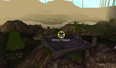
Inscription
Before the Hollowing this spot, known as Lookout Point, was a favorite destination for lovers on a midnight stroll. Now, it is a vantage point from which heroes keep their eyes on the mystical antics of the Circle of Thorns.
Location
This plaque is in The Hollows.
Its coordinates are (872, 68, 3344) . It is 571 yards east and slightly south of the Skyway City Entrance marker and 714 yards due south of the Red River Marker.
